Vision
The integration of digital technology with community participation and local governance structures offers a transformative approach to improving the quality of life in villages. By leveraging data-driven tools and GIS-based platforms like Gram Manchitra, Gram Panchayats can make informed decisions, enhance transparency, and foster self-sufficiency, laying the foundation for sustainable development.
This approach combines cutting-edge technology with the collective wisdom of local communities, enabling effective resource planning, monitoring, and execution of development initiatives. To achieve meaningful and long-lasting results, it is essential to customize these solutions to address the unique needs, priorities, and capacities of each village, ensuring their relevance and successful adoption.
Objectives
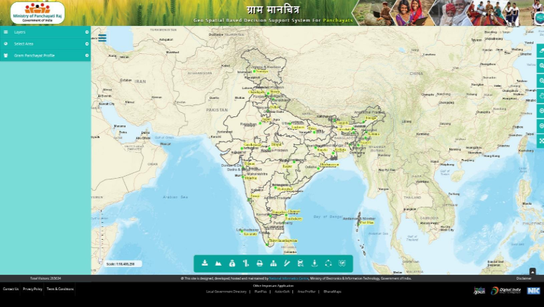
The Gram Manchitra application www.grammanchitra.gov.in has been designed with specific objectives to empower rural governance and enhance the quality of life in villages:
- Promoting Structured Planning: By utilizing geo-spatial technology, the application encourages resource-efficient and structured planning for rural development.
- Supporting GPDPs: Gram Manchitra plays a pivotal role in the preparation and implementation of GPDPs, enabling data-driven decisions for project planning and resource allocation.
- Enhancing Transparency and Accountability: Integration with tools like mActionSoft ensures that developmental works are traceable and geo-tagged, fostering transparency and accountability at all stages.
- Leveraging SVAMITVA Scheme: High-resolution maps at a 1:500 scale, generated under the SVAMITVA Scheme, provide detailed data for land and property management, as well as solar energy potential assessments.
- Facilitating Sustainable Development Goals (SDGs): The application embeds SDGs into local development plans, ensuring balanced and inclusive growth at the village level.
- Empowering Data-Driven Decision-Making: Comprehensive tools and features empower Gram Panchayats to visualize, analyze, and implement development initiatives effectively.
- Fostering Inclusive Growth: By providing a decision-support system tailored to the unique needs of each village, Gram Manchitra ensures that no community is left behind in the development process.
Key Features
The Gram Manchitra application is equipped with a wide array of features that aim to revolutionize rural planning and development. These advanced functionalities empower Gram Panchayats to make data-driven decisions for better governance and resource utilization:
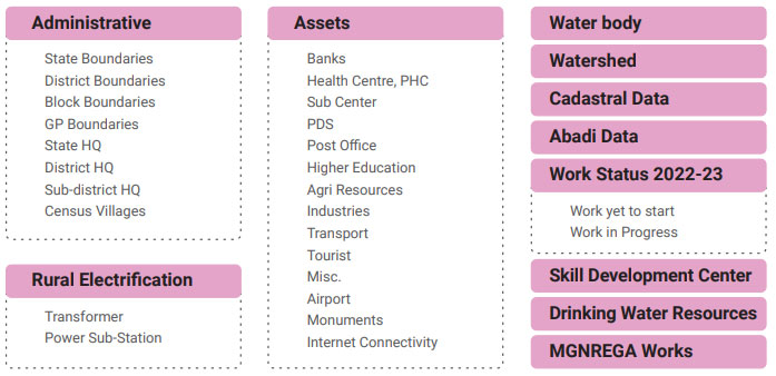
- Visualization Platform: Offers an intuitive, user-friendly interface to view and analyze developmental plans and resources.
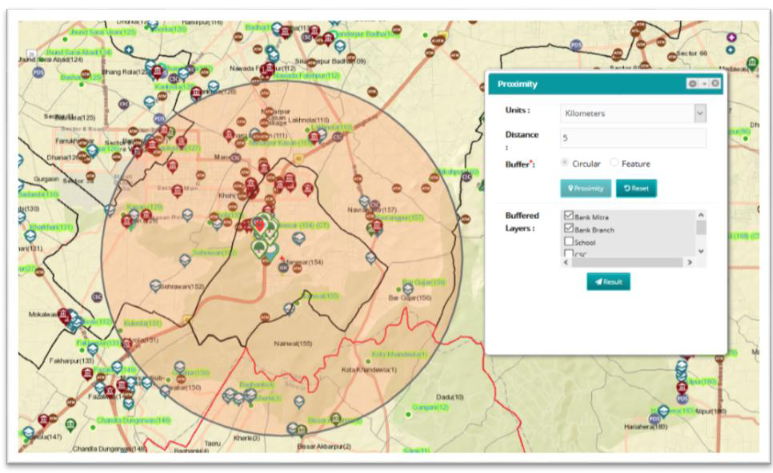
- Advanced Spatial Analysis Tools: Includes tools such as Solar Tool, Street Light Analysis, and Proximity Tool, which assist in identifying optimal locations for infrastructure and amenities.
- Geo-Tagging Integration: Through mActionSoft, developmental works are geo-tagged with GPS coordinates and photographs, ensuring transparency and real-time monitoring.
- Comprehensive Gram Panchayat Profiles: Provides detailed demographic, economic, and resource information for each Gram Panchayat.
- DIGIPIN Integration: Simplifies address identification in rural areas, providing precise location-based details, especially useful for areas lacking formal address systems.
- Natural Layers Integration: Incorporates critical data on natural resources such as rivers, dams, wildlife sanctuaries, and coastal zones to support environmentally sustainable planning.
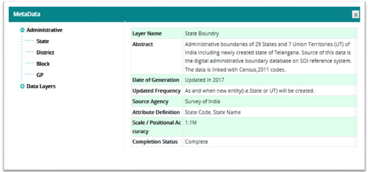
- Reports and Metadata: Generates sector-specific reports (e.g., health, education, public distribution systems) and ensures transparency with detailed metadata for all spatial layers.
- Resource Envelope: Displays fund allocations for various schemes, aiding financial planning and management.
Integrations and Collaborations
Gram Manchitra operates as a core part of a broader ecosystem, integrating seamlessly with flagship schemes and applications to enhance its functionality and usability. Key integrations include:
- eGramSwaraj: Linked with eGramSwaraj, Gram Manchitra allows users to plan, execute, and monitor developmental works aligned with the GPDP framework. This integration ensures efficient planning, budgeting, and resource allocation.
- mActionSoft: Enables geo-tagging of assets at all stages of development (before, during, and after completion), enhancing transparency and real-time monitoring.
- SVAMITVA Scheme: Data from the SVAMITVA Scheme is used in applications like the PM Surya Ghar Portal, which assesses the solar potential of rooftops. This integration promotes renewable energy adoption and supports sustainable development initiatives.
- BharatNet Project: The BharatNet Project, which connects Gram Panchayats with high-speed broadband, enhances the usability of Gram Manchitra by ensuring reliable access to digital tools and geospatial resources, thereby strengthening digital governance at the grassroots level.
- AuditOnline: Integrated with AuditOnline, Gram Manchitra supports transparency by facilitating the online auditing of Panchayat accounts. This ensures accountability and good governance by providing detailed, verifiable records of financial transactions.
Through these integrations, Gram Manchitra becomes a comprehensive platform that not only supports planning and monitoring but also promotes transparency, accountability, and the adoption of sustainable practices in rural governance.